FAA Part 107 study guide with diagrams — part of the Sky107 UAG knowledge test preparation course.
1. Overview of Sectional Charts and Aeronautical Symbols
VFR sectional charts are the primary visual navigation charts used by pilots operating under visual flight rules. For remote pilots operating under 14 CFR Part 107, the sectional chart is an essential preflight planning tool. It provides critical information about:
Controlled and uncontrolled airspace boundaries and vertical limits
Airport locations, types, elevations, runway lengths, and communication frequencies
Terrain elevations and man-made obstacle heights
Special use airspace, including restricted, prohibited, alert, and other areas
Navigational aids and visual landmarks
Remote pilots must understand the color coding, line styles, and symbols used on sectional charts to determine where they may operate, what authorizations are required, and what hazards to avoid. The FAA Aeronautical Chart User’s Guide is the authoritative reference for all chart symbology.
2. Airport Depiction and Color Coding
2.1 Blue vs. Magenta Airports
Airport symbols on VFR sectional charts are color-coded to indicate whether the airport has an operating control tower.
Blue airport symbols indicate an airport with an operating control tower.
Magenta airport symbols indicate an airport without an operating control tower.
This distinction is critical because it helps the remote pilot anticipate the type of airspace surrounding the airport and the likelihood of controlled airspace that requires ATC authorization.
2.2 Airport Information Block
Each airport symbol is accompanied by a data block containing important information. A typical format includes:
Airport elevation in feet MSL
Longest runway length in hundreds of feet
For example, the notation “1,200/35” next to an airport symbol means:
Field elevation: 1,200 feet MSL
Longest runway: 3,500 feet
This information helps the remote pilot understand the local terrain elevation and airport size, which is important for mission planning and altitude calculations.
3. Airspace Classification and Chart Depiction
One of the most important uses of sectional charts for remote pilots is identifying controlled and uncontrolled airspace. Each airspace class has a distinct chart depiction and specific Part 107 operating requirements.
3.1 Class B Airspace
Depiction: Solid blue lines
Structure: Multiple concentric circles surrounding the primary airport, generally extending from the surface upward to a specified MSL altitude
Chart markings: Altitude boxes indicate the ceiling and floor of each shelf in hundreds of feet MSL. The ceiling is shown as the top number and the floor as the bottom number. For example, “30/15” means the shelf extends from 1,500 feet MSL to 3,000 feet MSL.
Part 107 requirement: A remote pilot must obtain ATC authorization before operating in Class B airspace. This authorization is normally obtained through LAANC or FAA DroneZone.
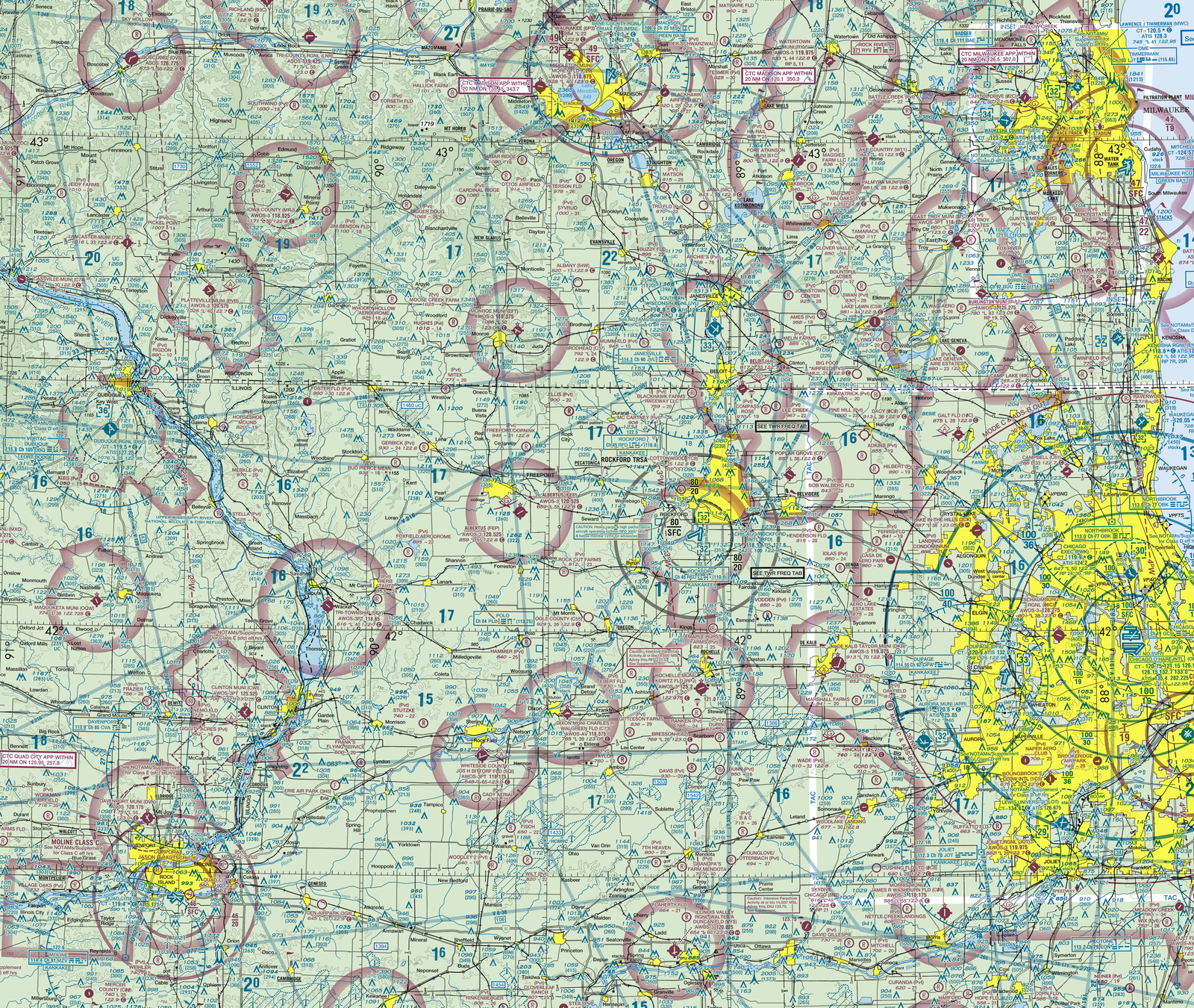
Real FAA Chicago Sectional Chart excerpt: the concentric blue rings are the Class B shelves around ORD and MDW. Each shelf is labeled with a ceiling/floor pair in hundreds of feet MSL — for example, "100/SFC" means the shelf starts at the surface and tops out at 10,000 ft MSL.
3.2 Class C Airspace
Depiction: Solid magenta lines
Structure: Typically consists of an inner surface area and an outer shelf area around a towered airport with radar approach control
Vertical extent: The inner area normally extends from the surface to about 4,000 feet AGL. The outer shelf typically begins at a higher floor and extends to the same ceiling. Altitude numbers inside the charted area indicate ceilings and floors in hundreds of feet MSL.
Part 107 requirement: Prior ATC authorization is required before operating in Class C airspace, obtained through LAANC or FAA DroneZone.
3.3 Class D Airspace
Depiction: Dashed blue lines, usually a single dashed blue circle around the airport
Structure: Extends from the surface upward to a specified altitude, typically around 2,500 feet AGL, with a ceiling indicated near the airport symbol
Important operational consideration: Class D airspace normally exists only when the associated control tower is operating. When the tower is closed, the airspace may become Class E surface area or Class G. Remote pilots must check the current airspace status using NOTAMs, chart supplements, and the airport operating hours.
Part 107 requirement: Prior ATC authorization is required to operate in Class D airspace when it is active. This differs from manned aircraft requirements—manned pilots only need to establish two-way radio communication.
3.4 Class E Airspace
Class E airspace is controlled airspace that exists in several forms, but two forms are especially important for remote pilots:
Surface-Based Class E Airspace
Depiction:Dashed magenta lines surrounding an airport
Significance: Indicates Class E airspace beginning at the surface, commonly found around non-towered airports with instrument approach procedures
Part 107 requirement: Prior ATC authorization is required to operate in Class E surface area because it is controlled airspace. Authorization is obtained through LAANC or FAA DroneZone.
Class E Airspace with a Solid Magenta Line
Some charts depict surface-based Class E using a solid magenta line. In some cases, the solid magenta line with a number such as “30” inside indicates the ceiling of a Class E surface area in hundreds of feet MSL, though the specific depiction can vary. Remote pilots should consult the chart legend and FAA Aeronautical Chart User’s Guide for the exact representation.
Class E Transition and En Route Areas
Class E airspace may also begin at 700 feet AGL or 1,200 feet AGL and extend upward. These areas are not normally shown with boundary lines. Part 107 operations are limited to 400 feet AGL, so these higher Class E floors generally do not require authorization unless the operation is conducted under a waiver or near a structure allowing higher altitude.
3.5 Class G Airspace
Class G airspace is uncontrolled airspace. It is depicted by the absence of controlled airspace boundaries. Part 107 remote pilots do not require ATC authorization to operate in Class G airspace, but they must still comply with all other Part 107 operating rules.
3.6 The Mode C Veil
Depiction: A dashed magenta line, often with a “30” marking, surrounding Class B airspace
Purpose: Within 30 nautical miles of a Class B primary airport, aircraft operating above a certain altitude must have Mode C transponder equipment. This requirement does not directly apply to Part 107 operations unless the UAS is equipped with an ADS-B Out system, but the remote pilot must still recognize the airspace depiction.
3.7 Airspace Authorization Summary Table
Airspace
Depiction
Part 107 Authorization Required?
Class B
Solid blue lines
Yes—ATC authorization via LAANC or DroneZone
Class C
Solid magenta lines
Yes—ATC authorization via LAANC or DroneZone
Class D
Dashed blue lines
Yes—when active; ATC authorization via LAANC or DroneZone
Class E (surface)
Dashed magenta lines or solid magenta lines
Yes—ATC authorization via LAANC or DroneZone
Class E (700/1,200 ft AGL and above)
Not directly depicted
No for normal Part 107 flights below 400 ft AGL
Class G
Unmarked
No
4. Obstacle and Terrain Depiction
4.1 Obstacle Symbols
Man-made obstructions such as towers, antennas, chimneys, and buildings are depicted on sectional charts with distinct symbols.
Single obstacle: A small star or asterisk-like symbol, often with the top elevation printed nearby in feet MSL. For example, an obstacle labeled “2440” has a top elevation of 2,440 feet MSL.
Group obstacle: A small magenta square with a number indicates a cluster of obstructions. The number gives the highest point elevation in feet MSL. This is particularly useful for avoiding multiple hazards in an industrial or urban area.
Significance for remote pilots: These obstacle elevations are used by remote pilots to maintain safe clearance from obstacles. Part 107 operations are limited to 400 feet AGL, but a remote pilot may fly higher when operating within 400 feet of a structure. Knowing the exact height of nearby structures in MSL is essential for safe operations and for proper altitude planning.
4.2 Maximum Elevation Figure (MEF)
The Maximum Elevation Figure is a critical preflight planning tool printed on sectional charts.
Location: Appears in each quadrangle of the sectional chart, typically in a large number surrounded by a blue boundary or shaded area.
Meaning: The MEF represents the highest terrain elevation or man-made obstacle height within that quadrangle, rounded upward to the next hundred feet and expressed in thousands and hundreds of feet MSL.
Interpretation: A MEF of “12” means 1,200 feet MSL. A MEF of “47” means 4,700 feet MSL, not 47,000 feet. A MEF of “48” means 4,800 feet MSL.
Purpose: The MEF provides a conservative reference for terrain and obstacle clearance. A remote pilot planning a mission below a certain MSL altitude can use the MEF to ensure the aircraft remains clear of the highest known terrain or obstacle in that area.
Not a regulatory limit: The MEF is not an operational ceiling or a Part 107 restriction. The altitude limits for sUAS are found in 14 CFR 107.51, which establishes the 400-foot AGL basic limit and the structure-related exception.
4.3 Applying MEF and Obstacle Data to UAS Flight Planning
When planning a UAS mission, the remote pilot should:
81.Identify the MEF for the operating quadrangle.
82.Identify all charted obstacles near the planned flight path.
83.Compare the intended maximum MSL altitude of the UAS with the MEF and obstacle elevations to ensure terrain and obstacle clearance.
84.Conduct an on-site visual inspection to identify any uncharted obstacles, such as newly erected towers, cranes, or buildings, which may not yet be on the sectional chart.
5. Special Use Airspace
Special use airspace consists of areas with specific restrictions or hazards. Remote pilots must recognize these areas on sectional charts and understand their operational implications.
5.1 Prohibited Areas
Label: The letter “P” followed by a number, such as “P-56”
Depiction: Blue hatched boundary
Meaning: Areas where flight is prohibited for national security or public safety reasons. A well-known example is P-56 near Washington, D.C.
Part 107 rule: No aircraft, including sUAS, may operate in a prohibited area without authorization from the using agency. Remote pilots must ensure both the launch point and flight path do not enter prohibited areas.
5.2 Restricted Areas
Label: The letter “R” followed by a number, such as “R-2508” or “R-5002”
Depiction: Blue hatched boundary
Meaning: Areas where hazardous military or other activities occur, such as artillery firing, guided missiles, or high-speed military aircraft operations.
Part 107 rule: Operation in a restricted area without permission from the using or controlling agency is prohibited. Restricted areas may be “hot” (active) or “cold” (inactive). The remote pilot must check NOTAMs or the controlling agency before flight to determine the active status. If the area is hot, the pilot must avoid it or obtain prior permission.
5.3 Alert Areas
Depiction:Magenta dashed line with the words “Alert Area” printed inside
Meaning: Areas with a high volume of pilot training or unusual aerial activity. They alert pilots to be especially vigilant for concentrated flight activity.
Part 107 rule: Alert areas are not prohibited or restricted. Operations are permitted, but the remote pilot must exercise increased vigilance and maintain the ability to see and avoid manned aircraft.
5.4 Other Special Use Areas
Remote pilots should also be aware of:
Military Operations Areas (MOAs): Charted areas where military training occurs. sUAS operations may be permitted, but the pilot should be alert for high-speed military traffic.
Warning Areas: Extend beyond the coastline and are not normally relevant to Part 107 operations within U.S. airspace.
Controlled Firing Areas: Depicted on some charts and indicate areas of hazardous activity. Operations may be permitted when the area is not active.
5.5 Special Use Airspace Status
Temporary and current status of restricted areas, MOAs, and other special use airspace is available through:
NOTAMs
The controlling agency
The FAA Chart Supplement U.S.
The remote pilot must check the active status of these areas before every flight that may be affected.
6. Temporary Flight Restrictions (TFRs)
6.1 Nature of TFRs
Temporary Flight Restrictions are issued by the FAA to restrict flight operations in a specific area for a limited time. TFRs are established for reasons such as:
VIP movement (presidential or other high-level official travel)
14 CFR §107.47 – Flight restrictions: Remote pilots must comply with temporary flight restrictions and other flight restrictions designated by NOTAM in the proximity of certain areas (§107.47, referencing 14 CFR §§91.137–91.145 and 99.7). This is the regulatory hook that makes operating inside an active TFR a Part 107 violation.
6.2 Chart Depiction
TFRs are not printed on sectional charts because they are temporary by nature. They are issued and updated through NOTAMs.
6.3 Locating TFRs
The most reliable and current method to check for TFRs is to check NOTAMs. Sources include:
The FAA’s NOTAM search tools
Flight service stations
Approved aviation weather and flight planning apps
The FAA’s TFR website
6.4 Part 107 Requirements
Under 14 CFR 107.43, a remote pilot in command must not operate in the area of a TFR unless they have received authorization from the appropriate authority. Under 14 CFR 107.45, the remote pilot must not operate in prohibited or restricted areas, and must be aware of all relevant airspace restrictions. Preflight planning must include a check for TFRs.
7. Airport Communication Frequencies
7.1 Control Tower Frequency
Depiction: Often shown near the airport symbol, with the abbreviation “CT” and a frequency such as “118.9” or “125.15”
Meaning: The frequency of the airport control tower.
Use by remote pilots: While Part 107 pilots do not normally communicate directly with ATC for airspace authorization, understanding the tower frequency is part of airspace situational awareness. Manned aircraft use the control tower frequency for communication.
7.2 Common Traffic Advisory Frequency (CTAF)
Definition: The CTAF is the frequency used by pilots to announce their positions and intentions when operating at airports without an operating control tower, or when the tower is closed.
Chart depiction: Listed near the airport symbol, often with the abbreviation “CTAF” and the frequency, such as “122.8”.
Use by remote pilots: Part 107 does not require remote pilots to carry or use a radio on the CTAF. However, monitoring the CTAF and making position announcements is a recommended safety practice when operating near an uncontrolled airport. This increases situational awareness and helps the remote pilot avoid conflicts with manned aircraft operating in the traffic pattern.
Tower closed: When a towered airport’s tower is closed, the CTAF becomes the common frequency for pilots to broadcast their positions. Remote pilots operating near such an airport should monitor and announce on the CTAF.
UNICOM: A UNICOM (universal communications) frequency is a non-air traffic control frequency used at many airports to provide airport advisory information, fuel availability, weather, and other services. Unlike the CTAF, UNICOM is not used for position announcements in the traffic pattern; it is a two-way communications frequency typically monitored by a fixed-base operator (FBO) or airport staff. Remote pilots may monitor UNICOM to obtain airport information, but position announcements are made on the CTAF.
7.3 Recommended CTAF Practices for Remote Pilots
Monitor the CTAF before and during operations near uncontrolled airports.
Announce the remote operation’s location and altitude if a radio is available.
Yield the right of way to all manned aircraft, as required by 14 CFR 107.37.
Use CTAF information to anticipate manned aircraft activity.
8. Preflight Planning and Aeronautical Charts
8.1 Chart Currency
Sectional charts are updated on a regular cycle, typically every 56 days for most areas. Remote pilots should use the most current chart available and supplement chart information with current NOTAMs and other temporary data.
8.2 Authoritative Sources
FAA Aeronautical Chart User’s Guide: The authoritative reference for understanding all chart symbols and their meanings.
Chart Supplement U.S.: Provides additional airport information, including hours of operation, traffic patterns, frequencies, and special notes not shown on the sectional chart.
NOTAMs: Provide current temporary changes, airspace restrictions, TFRs, and special notices.
FAA DroneZone and LAANC: Provide airspace authorization for controlled airspace operations.
8.3 Required Preflight Actions for Remote Pilots
Before each Part 107 operation, the remote pilot in command should:
160.Obtain current weather and forecast information.
161.Check NOTAMs for TFRs, airspace changes, and special notices.
162.Review the sectional chart for the operating area, including airspace class, MEF, obstacles, and special use airspace.
163.Determine if the flight will occur in controlled airspace requiring authorization.
164.Identify the status of any local airport control towers and airspace activation.
165.Review CTAF and other communication frequencies if operating near airports.
166.Identify obstacles and terrain that may affect the flight path.
167.Verify that the proposed operation complies with all Part 107 operating rules.
8.4 Regulatory References for Preflight
14 CFR 91.103: Requires pilots to become familiar with all available information concerning the flight, including runway lengths, weather, fuel, takeoff and landing distances, and alternatives. While Part 91 directly applies to manned aircraft, the standard of preflight preparation is relevant to remote pilots.
14 CFR Part 107.49: Requires the remote pilot in command to ensure that all necessary operational information is available and understood before conducting a small UAS operation.
9. Common Relationships and Practical Applications
9.1 Airspace Color and Line Style Relationships
Feature
Solid Line
Dashed Line
Hatched Area
**Blue**
Class B airspace
Class D airspace
Restricted or Prohibited area
**Magenta**
Class C airspace or surface-based Class E
Class E surface area, Mode C veil, or Alert area
—
9.2 Airport Color and Airspace Relationship
A blue airport (towered) is commonly associated with Class B, C, or D airspace. Remote pilots should anticipate controlled airspace and check for authorization requirements.
A magenta airport (non-towered) may be surrounded by Class E surface area or Class G airspace. If Class E surface area is depicted with dashed magenta lines, authorization is required.
9.3 Elevation References
MEF is the highest terrain or obstacle in a quadrangle, rounded upward to the next hundred feet MSL.
Obstacle labels give specific top elevations in feet MSL.
Airport data blocks give field elevation in feet MSL.
Part 107 altitude limit is 400 feet AGL, with possible higher operations near structures. The remote pilot must convert MSL and AGL elevations properly when planning a mission to avoid terrain and obstacles.
9.4 Airspace Authorization vs. Airspace Awareness
Remote pilots must understand the difference between:
ATC authorization for operating in controlled airspace (Classes B, C, D, and surface-based E), which is obtained through LAANC or FAA DroneZone, and
Monitoring and avoidance in uncontrolled airspace or alert areas, where no authorization is required but vigilance is essential.
9.5 Special Use Airspace Decision Flow
When encountering special use airspace on a sectional chart:
190.Identify the type by the label and hatching:
P: Prohibited—do not enter.
R: Restricted—check active status; avoid if hot or obtain permission.
Alert: Increased vigilance; operations permitted but monitored closely.
194.Check current status through NOTAMs or the controlling agency.
195.Plan the route to avoid active hazardous areas.
196.Document the preflight briefing for compliance and safety records.
10. Summary of Key Chart Symbols for Part 107 Remote Pilots
Symbol
Meaning
Part 107 Action
Solid blue line
Class B airspace
Obtain ATC authorization before flight
Solid magenta line
Class C airspace or Class E surface area (depending on context)
Obtain ATC authorization before flight
Dashed blue line
Class D airspace
Obtain ATC authorization before flight when active
Dashed magenta line
Class E surface area, Mode C veil, or Alert area
Determine which; obtain authorization if Class E surface area
Blue airport symbol
Towered airport
Check for associated controlled airspace
Magenta airport symbol
Non-towered airport
Monitor CTAF; check for Class E surface area
Airport data block “1,200/35”
Elevation 1,200 ft MSL, longest runway 3,500 ft
Use for terrain reference and flight planning
Star or asterisk obstacle symbol with number
Obstacle top elevation in feet MSL
Avoid obstacle; consider altitude planning
Magenta square with number
Group obstacle highest elevation in feet MSL
Avoid group of obstacles; consider altitude planning
MEF number “12” or “47”
Highest terrain/obstacle in quadrangle, thousands/hundreds ft MSL
Conservative terrain and obstacle clearance reference
Blue hatched “R” area
Restricted area
Check NOTAMs for active status; avoid if hot
Blue hatched “P” area
Prohibited area
Do not enter; no authorization for Part 107
Magenta dashed “Alert Area”
High volume of pilot training or unusual aerial activity
Operate with increased vigilance; yield right of way
“CT” with frequency
Control tower frequency
Situational awareness; not normally used by UAS
“CTAF” with frequency
Common Traffic Advisory Frequency
Monitor and announce for safety near uncontrolled airports
11. Conclusion
A thorough understanding of VFR sectional charts and aeronautical symbols is essential for the safe and legal operation of small unmanned aircraft systems under Part 107. The remote pilot in command must be able to identify airspace boundaries, airport types, obstacles, terrain elevations, and special use airspace before every flight. This knowledge enables the remote pilot to determine the need for airspace authorization, assess terrain and obstacle hazards, and maintain situational awareness of manned aircraft traffic. By combining chart interpretation with current NOTAMs, chart supplements, and LAANC/DroneZone authorization processes, the remote pilot can conduct operations safely and in compliance with FAA regulations.